|
|
|||||||||||||||||
| Point ID: 8606 | Downloads | Plots | Site Data | Code: 11217 |
|
|
|||||||||||||||||
| Download | |
|---|---|
| Site Descriptor Information | Site Time Series Data |
| Link to all available data | |
| View: | Time Series | All |
| Units: | mm |
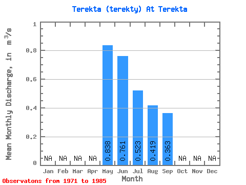
| Statistic | Jan | Feb | Mar | Apr | May | Jun | Jul | Aug | Sep | Oct | Nov | Dec | Annual |
|---|---|---|---|---|---|---|---|---|---|---|---|---|---|
| Mean | 0.84 | 0.76 | 0.52 | 0.42 | 0.36 | ||||||||
| Standard Deviation | 0.57 | 0.49 | 0.37 | 0.34 | 0.29 | ||||||||
| Min | 0.25 | 0.19 | 0.14 | 0.11 | 0.10 | ||||||||
| Max | 2.14 | 1.80 | 1.60 | 1.47 | 1.32 | ||||||||
| Coefficient of Variation | 0.68 | 0.65 | 0.71 | 0.81 | 0.81 |
 Return to R-Arctic Net Home Page