|
|
|||||||||||||||||
| Point ID: 8606 | Downloads | Plots | Site Data | Code: 11217 |
|
|
|||||||||||||||||
| Download | |
|---|---|
| Site Descriptor Information | Site Time Series Data |
| Link to all available data | |
| View: | Time Series | All |
| Units: | m3/s |
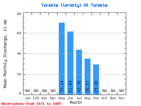
| Statistic | Jan | Feb | Mar | Apr | May | Jun | Jul | Aug | Sep | Oct | Nov | Dec | Annual |
|---|---|---|---|---|---|---|---|---|---|---|---|---|---|
| Mean | 70.13 | 61.67 | 43.80 | 35.09 | 29.43 | ||||||||
| Standard Deviation | 47.72 | 39.92 | 31.13 | 28.61 | 23.77 | ||||||||
| Min | 20.92 | 15.39 | 11.72 | 9.21 | 8.10 | ||||||||
| Max | 179.09 | 145.80 | 133.90 | 123.02 | 106.92 | ||||||||
| Coefficient of Variation | 0.68 | 0.65 | 0.71 | 0.81 | 0.81 |
 Return to R-Arctic Net Home Page