|
|
|||||||||||||||||
| Point ID: 86 | Downloads | Plots | Site Data | Code: 05AD005 |
|
|
|||||||||||||||||
| Download | |
|---|---|
| Site Descriptor Information | Site Time Series Data |
| Link to all available data | |
| View: | Time Series | All |
| Units: | mm |
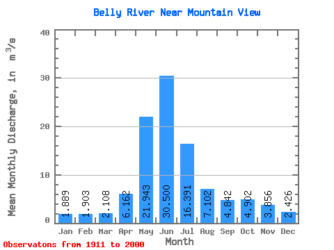
| Statistic | Jan | Feb | Mar | Apr | May | Jun | Jul | Aug | Sep | Oct | Nov | Dec | Annual |
|---|---|---|---|---|---|---|---|---|---|---|---|---|---|
| Mean | 1.89 | 1.90 | 2.11 | 6.16 | 21.94 | 30.50 | 16.39 | 7.10 | 4.84 | 4.90 | 3.86 | 2.43 | 8.67 |
| Standard Deviation | 0.73 | 0.94 | 1.03 | 3.12 | 5.50 | 11.74 | 6.64 | 2.59 | 2.61 | 2.78 | 2.24 | 1.21 | 2.06 |
| Min | 0.71 | 0.73 | 0.82 | 1.74 | 9.46 | 9.63 | 3.98 | 1.63 | 1.40 | 1.29 | 1.17 | 0.77 | 4.25 |
| Max | 5.43 | 5.73 | 6.33 | 20.20 | 36.80 | 69.30 | 36.20 | 14.70 | 14.60 | 13.80 | 13.00 | 8.41 | 14.13 |
| Coefficient of Variation | 0.39 | 0.49 | 0.49 | 0.51 | 0.25 | 0.39 | 0.41 | 0.36 | 0.54 | 0.57 | 0.58 | 0.50 | 0.24 |
 Return to R-Arctic Net Home Page