|
|
|||||||||||||||||
| Point ID: 86 | Downloads | Plots | Site Data | Code: 05AD005 |
|
|
|||||||||||||||||
| Download | |
|---|---|
| Site Descriptor Information | Site Time Series Data |
| Link to all available data | |
| View: | Time Series | All |
| Units: | m3/s |
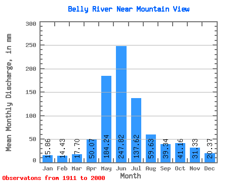
| Statistic | Jan | Feb | Mar | Apr | May | Jun | Jul | Aug | Sep | Oct | Nov | Dec | Annual |
|---|---|---|---|---|---|---|---|---|---|---|---|---|---|
| Mean | 15.86 | 14.55 | 17.69 | 50.07 | 184.21 | 247.83 | 137.60 | 59.62 | 39.34 | 41.16 | 31.33 | 20.36 | 857.61 |
| Standard Deviation | 6.16 | 7.15 | 8.65 | 25.37 | 46.16 | 95.42 | 55.73 | 21.75 | 21.19 | 23.34 | 18.23 | 10.16 | 203.52 |
| Min | 5.93 | 5.58 | 6.89 | 14.14 | 79.42 | 78.25 | 33.41 | 13.68 | 11.38 | 10.83 | 9.51 | 6.45 | 420.25 |
| Max | 45.59 | 43.83 | 53.14 | 164.13 | 308.94 | 563.09 | 303.90 | 123.41 | 118.63 | 115.85 | 105.63 | 70.60 | 1398.43 |
| Coefficient of Variation | 0.39 | 0.49 | 0.49 | 0.51 | 0.25 | 0.39 | 0.41 | 0.36 | 0.54 | 0.57 | 0.58 | 0.50 | 0.24 |
 Return to R-Arctic Net Home Page