|
|
|||||||||||||||||
| Point ID: 8594 | Downloads | Plots | Site Data | Code: 11183 |
|
|
|||||||||||||||||
| Download | |
|---|---|
| Site Descriptor Information | Site Time Series Data |
| Link to all available data | |
| View: | Time Series | All |
| Units: | mm |
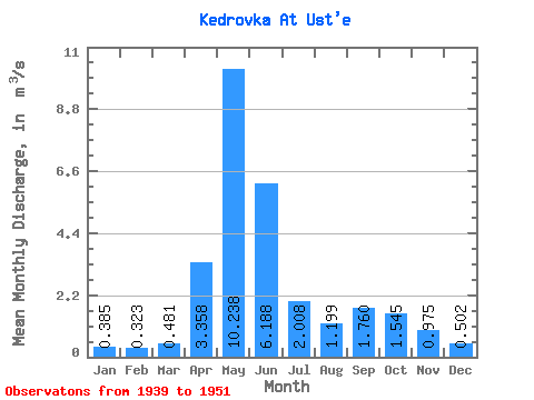
| Statistic | Jan | Feb | Mar | Apr | May | Jun | Jul | Aug | Sep | Oct | Nov | Dec | Annual |
|---|---|---|---|---|---|---|---|---|---|---|---|---|---|
| Mean | 0.39 | 0.32 | 0.48 | 3.36 | 10.24 | 6.19 | 2.01 | 1.20 | 1.76 | 1.54 | 0.97 | 0.50 | 2.41 |
| Standard Deviation | 0.10 | 0.09 | 0.24 | 1.11 | 1.96 | 3.32 | 1.21 | 0.85 | 2.04 | 0.97 | 0.48 | 0.16 | 0.77 |
| Min | 0.23 | 0.16 | 0.24 | 1.69 | 6.05 | 1.15 | 0.43 | 0.29 | 0.28 | 0.70 | 0.50 | 0.29 | 1.04 |
| Max | 0.56 | 0.44 | 1.00 | 5.59 | 13.50 | 11.90 | 4.48 | 3.04 | 8.23 | 4.14 | 2.23 | 0.87 | 4.15 |
| Coefficient of Variation | 0.25 | 0.26 | 0.50 | 0.33 | 0.19 | 0.54 | 0.60 | 0.71 | 1.16 | 0.63 | 0.49 | 0.32 | 0.32 |
 Return to R-Arctic Net Home Page