|
|
|||||||||||||||||
| Point ID: 8594 | Downloads | Plots | Site Data | Code: 11183 |
|
|
|||||||||||||||||
| Download | |
|---|---|
| Site Descriptor Information | Site Time Series Data |
| Link to all available data | |
| View: | Time Series | All |
| Units: | m3/s |
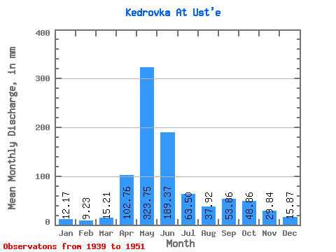
| Statistic | Jan | Feb | Mar | Apr | May | Jun | Jul | Aug | Sep | Oct | Nov | Dec | Annual |
|---|---|---|---|---|---|---|---|---|---|---|---|---|---|
| Mean | 12.19 | 9.31 | 15.20 | 102.78 | 323.71 | 189.36 | 63.48 | 37.92 | 53.86 | 48.84 | 29.82 | 15.88 | 899.30 |
| Standard Deviation | 3.06 | 2.44 | 7.55 | 34.03 | 62.05 | 101.64 | 38.29 | 26.96 | 62.56 | 30.76 | 14.64 | 5.15 | 288.05 |
| Min | 7.27 | 4.61 | 7.59 | 51.72 | 191.29 | 35.19 | 13.60 | 9.17 | 8.57 | 22.13 | 15.30 | 9.17 | 389.07 |
| Max | 17.71 | 12.68 | 31.62 | 171.07 | 426.84 | 364.17 | 141.65 | 96.12 | 251.85 | 130.90 | 68.24 | 27.51 | 1545.71 |
| Coefficient of Variation | 0.25 | 0.26 | 0.50 | 0.33 | 0.19 | 0.54 | 0.60 | 0.71 | 1.16 | 0.63 | 0.49 | 0.32 | 0.32 |
 Return to R-Arctic Net Home Page