|
|
|||||||||||||||||
| Point ID: 8593 | Downloads | Plots | Site Data | Code: 11182 |
|
|
|||||||||||||||||
| Download | |
|---|---|
| Site Descriptor Information | Site Time Series Data |
| Link to all available data | |
| View: | Time Series | All |
| Units: | mm |
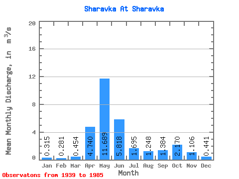
| Statistic | Jan | Feb | Mar | Apr | May | Jun | Jul | Aug | Sep | Oct | Nov | Dec | Annual |
|---|---|---|---|---|---|---|---|---|---|---|---|---|---|
| Mean | 0.32 | 0.28 | 0.45 | 4.74 | 11.69 | 5.82 | 1.69 | 1.25 | 1.38 | 2.17 | 1.11 | 0.44 | 2.65 |
| Standard Deviation | 0.14 | 0.17 | 0.38 | 1.81 | 3.12 | 4.51 | 1.11 | 1.01 | 1.01 | 1.31 | 0.70 | 0.21 | 0.74 |
| Min | 0.14 | 0.12 | 0.12 | 1.32 | 5.76 | 0.46 | 0.21 | 0.19 | 0.17 | 0.41 | 0.29 | 0.18 | 1.32 |
| Max | 0.76 | 0.87 | 1.93 | 9.59 | 17.30 | 18.80 | 4.15 | 4.00 | 5.59 | 5.27 | 3.89 | 1.12 | 4.09 |
| Coefficient of Variation | 0.46 | 0.61 | 0.84 | 0.38 | 0.27 | 0.78 | 0.66 | 0.81 | 0.73 | 0.60 | 0.64 | 0.48 | 0.28 |
 Return to R-Arctic Net Home Page