|
|
|||||||||||||||||
| Point ID: 8593 | Downloads | Plots | Site Data | Code: 11182 |
|
|
|||||||||||||||||
| Download | |
|---|---|
| Site Descriptor Information | Site Time Series Data |
| Link to all available data | |
| View: | Time Series | All |
| Units: | m3/s |
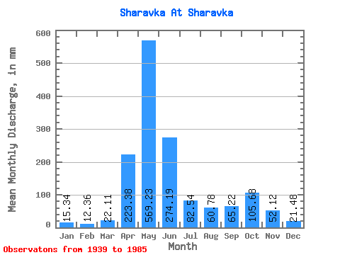
| Statistic | Jan | Feb | Mar | Apr | May | Jun | Jul | Aug | Sep | Oct | Nov | Dec | Annual |
|---|---|---|---|---|---|---|---|---|---|---|---|---|---|
| Mean | 15.36 | 12.48 | 22.10 | 223.37 | 569.15 | 274.17 | 82.53 | 60.76 | 65.21 | 105.66 | 52.10 | 21.47 | 1517.89 |
| Standard Deviation | 7.07 | 7.62 | 18.62 | 85.08 | 151.82 | 212.46 | 54.09 | 49.23 | 47.46 | 63.61 | 33.18 | 10.35 | 425.12 |
| Min | 6.82 | 5.32 | 5.84 | 62.21 | 280.46 | 21.68 | 10.22 | 9.25 | 8.01 | 19.96 | 13.67 | 8.76 | 759.83 |
| Max | 37.01 | 38.60 | 93.97 | 451.95 | 842.35 | 885.99 | 202.07 | 194.76 | 263.44 | 256.60 | 183.32 | 54.56 | 2346.44 |
| Coefficient of Variation | 0.46 | 0.61 | 0.84 | 0.38 | 0.27 | 0.78 | 0.66 | 0.81 | 0.73 | 0.60 | 0.64 | 0.48 | 0.28 |
 Return to R-Arctic Net Home Page