|
|
|||||||||||||||||
| Point ID: 8592 | Downloads | Plots | Site Data | Code: 11181 |
|
|
|||||||||||||||||
| Download | |
|---|---|
| Site Descriptor Information | Site Time Series Data |
| Link to all available data | |
| View: | Time Series | All |
| Units: | mm |
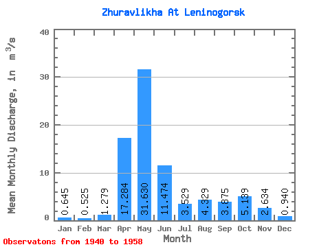
| Statistic | Jan | Feb | Mar | Apr | May | Jun | Jul | Aug | Sep | Oct | Nov | Dec | Annual |
|---|---|---|---|---|---|---|---|---|---|---|---|---|---|
| Mean | 0.65 | 0.53 | 1.28 | 17.28 | 31.63 | 11.47 | 3.53 | 4.33 | 3.88 | 5.14 | 2.63 | 0.94 | 6.94 |
| Standard Deviation | 0.17 | 0.12 | 1.48 | 7.26 | 10.42 | 6.15 | 2.31 | 3.96 | 5.75 | 3.95 | 1.48 | 0.29 | 2.14 |
| Min | 0.39 | 0.38 | 0.40 | 6.73 | 15.20 | 1.24 | 0.88 | 0.96 | 0.88 | 1.22 | 0.67 | 0.60 | 4.16 |
| Max | 0.90 | 0.77 | 5.32 | 30.60 | 53.20 | 21.00 | 7.87 | 11.90 | 20.00 | 15.20 | 4.55 | 1.42 | 11.53 |
| Coefficient of Variation | 0.27 | 0.24 | 1.16 | 0.42 | 0.33 | 0.54 | 0.66 | 0.91 | 1.48 | 0.77 | 0.56 | 0.30 | 0.31 |
 Return to R-Arctic Net Home Page