|
|
|||||||||||||||||
| Point ID: 8592 | Downloads | Plots | Site Data | Code: 11181 |
|
|
|||||||||||||||||
| Download | |
|---|---|
| Site Descriptor Information | Site Time Series Data |
| Link to all available data | |
| View: | Time Series | All |
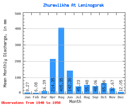
| Units: | m3/s |
| Statistic | Jan | Feb | Mar | Apr | May | Jun | Jul | Aug | Sep | Oct | Nov | Dec | Annual |
|---|---|---|---|---|---|---|---|---|---|---|---|---|---|
| Mean | 8.27 | 6.13 | 16.39 | 214.35 | 405.29 | 142.30 | 45.22 | 55.47 | 48.06 | 65.85 | 32.67 | 12.04 | 1048.02 |
| Standard Deviation | 2.20 | 1.45 | 19.00 | 90.07 | 133.50 | 76.26 | 29.64 | 50.70 | 71.26 | 50.60 | 18.30 | 3.67 | 323.82 |
| Min | 5.00 | 4.44 | 5.12 | 83.47 | 194.76 | 15.38 | 11.28 | 12.30 | 10.91 | 15.63 | 8.31 | 7.69 | 627.55 |
| Max | 11.53 | 8.99 | 68.17 | 379.50 | 681.67 | 260.44 | 100.84 | 152.48 | 248.04 | 194.76 | 56.44 | 18.20 | 1741.21 |
| Coefficient of Variation | 0.27 | 0.24 | 1.16 | 0.42 | 0.33 | 0.54 | 0.66 | 0.91 | 1.48 | 0.77 | 0.56 | 0.30 | 0.31 |
 Return to R-Arctic Net Home Page