|
|
|||||||||||||||||
| Point ID: 8588 | Downloads | Plots | Site Data | Code: 11174 |
|
|
|||||||||||||||||
| Download | |
|---|---|
| Site Descriptor Information | Site Time Series Data |
| Link to all available data | |
| View: | Time Series | All |
| Units: | mm |
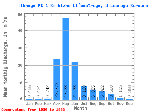
| Statistic | Jan | Feb | Mar | Apr | May | Jun | Jul | Aug | Sep | Oct | Nov | Dec | Annual |
|---|---|---|---|---|---|---|---|---|---|---|---|---|---|
| Mean | 0.46 | 0.42 | 0.74 | 23.77 | 47.28 | 21.78 | 8.16 | 6.08 | 5.02 | 3.56 | 1.20 | 0.37 | 9.26 |
| Standard Deviation | 0.58 | 0.49 | 0.74 | 11.52 | 22.10 | 21.11 | 7.15 | 6.46 | 8.65 | 4.85 | 1.52 | 0.37 | 3.66 |
| Min | 0.10 | 0.08 | 0.09 | 6.24 | 15.10 | 0.23 | 0.18 | 0.14 | 0.08 | 0.20 | 0.20 | 0.11 | 2.46 |
| Max | 3.01 | 2.57 | 2.71 | 44.30 | 120.00 | 86.00 | 24.80 | 24.30 | 42.00 | 18.40 | 6.65 | 2.05 | 18.25 |
| Coefficient of Variation | 1.27 | 1.15 | 1.00 | 0.48 | 0.47 | 0.97 | 0.88 | 1.06 | 1.72 | 1.36 | 1.27 | 0.99 | 0.40 |
 Return to R-Arctic Net Home Page