|
|
|||||||||||||||||
| Point ID: 8588 | Downloads | Plots | Site Data | Code: 11174 |
|
|
|||||||||||||||||
| Download | |
|---|---|
| Site Descriptor Information | Site Time Series Data |
| Link to all available data | |
| View: | Time Series | All |
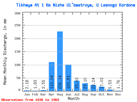
| Units: | m3/s |
| Statistic | Jan | Feb | Mar | Apr | May | Jun | Jul | Aug | Sep | Oct | Nov | Dec | Annual |
|---|---|---|---|---|---|---|---|---|---|---|---|---|---|
| Mean | 2.18 | 1.85 | 3.55 | 110.03 | 226.11 | 100.82 | 39.02 | 29.10 | 23.25 | 17.02 | 5.53 | 1.76 | 521.60 |
| Standard Deviation | 2.77 | 2.12 | 3.56 | 53.30 | 105.68 | 97.71 | 34.18 | 30.89 | 40.04 | 23.18 | 7.04 | 1.75 | 206.02 |
| Min | 0.48 | 0.35 | 0.43 | 28.88 | 72.21 | 1.06 | 0.86 | 0.67 | 0.37 | 0.96 | 0.93 | 0.53 | 138.40 |
| Max | 14.39 | 11.20 | 12.96 | 205.05 | 573.86 | 398.06 | 118.60 | 116.21 | 194.40 | 87.99 | 30.78 | 9.80 | 1028.61 |
| Coefficient of Variation | 1.27 | 1.15 | 1.00 | 0.48 | 0.47 | 0.97 | 0.88 | 1.06 | 1.72 | 1.36 | 1.27 | 0.99 | 0.40 |
 Return to R-Arctic Net Home Page