|
|
|||||||||||||||||
| Point ID: 8587 | Downloads | Plots | Site Data | Code: 11171 |
|
|
|||||||||||||||||
| Download | |
|---|---|
| Site Descriptor Information | Site Time Series Data |
| Link to all available data | |
| View: | Time Series | All |
| Units: | mm |
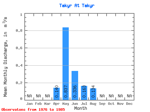
| Statistic | Jan | Feb | Mar | Apr | May | Jun | Jul | Aug | Sep | Oct | Nov | Dec | Annual |
|---|---|---|---|---|---|---|---|---|---|---|---|---|---|
| Mean | 0.14 | 0.84 | 0.34 | 0.16 | 0.13 | ||||||||
| Standard Deviation | 0.36 | 0.22 | 0.10 | 0.09 | |||||||||
| Min | 0.14 | 0.48 | 0.12 | 0.04 | 0.06 | ||||||||
| Max | 0.14 | 1.45 | 0.72 | 0.32 | 0.27 | ||||||||
| Coefficient of Variation | 0.43 | 0.67 | 0.63 | 0.67 |
 Return to R-Arctic Net Home Page