|
|
|||||||||||||||||
| Point ID: 8587 | Downloads | Plots | Site Data | Code: 11171 |
|
|
|||||||||||||||||
| Download | |
|---|---|
| Site Descriptor Information | Site Time Series Data |
| Link to all available data | |
| View: | Time Series | All |
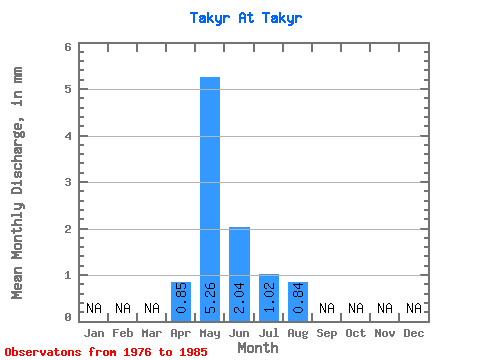
| Units: | m3/s |
| Statistic | Jan | Feb | Mar | Apr | May | Jun | Jul | Aug | Sep | Oct | Nov | Dec | Annual |
|---|---|---|---|---|---|---|---|---|---|---|---|---|---|
| Mean | 0.85 | 5.26 | 2.04 | 1.02 | 0.84 | ||||||||
| Standard Deviation | 2.26 | 1.36 | 0.64 | 0.56 | |||||||||
| Min | 0.85 | 3.02 | 0.73 | 0.23 | 0.40 | ||||||||
| Max | 0.85 | 9.12 | 4.38 | 2.01 | 1.70 | ||||||||
| Coefficient of Variation | 0.43 | 0.67 | 0.63 | 0.67 |
 Return to R-Arctic Net Home Page