|
|
|||||||||||||||||
| Point ID: 8572 | Downloads | Plots | Site Data | Code: 11132 |
|
|
|||||||||||||||||
| Download | |
|---|---|
| Site Descriptor Information | Site Time Series Data |
| Link to all available data | |
| View: | Time Series | All |
| Units: | mm |
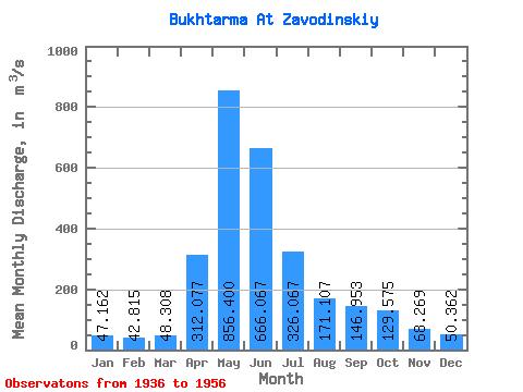
| Statistic | Jan | Feb | Mar | Apr | May | Jun | Jul | Aug | Sep | Oct | Nov | Dec | Annual |
|---|---|---|---|---|---|---|---|---|---|---|---|---|---|
| Mean | 47.16 | 42.81 | 48.31 | 312.08 | 856.40 | 666.07 | 326.07 | 171.11 | 146.95 | 129.57 | 68.27 | 50.36 | 226.64 |
| Standard Deviation | 8.18 | 7.18 | 5.95 | 133.40 | 202.90 | 266.39 | 130.77 | 48.65 | 59.60 | 51.46 | 21.05 | 11.56 | 46.72 |
| Min | 32.50 | 24.50 | 39.90 | 102.00 | 495.00 | 192.00 | 120.00 | 99.60 | 65.10 | 91.20 | 43.20 | 40.10 | 132.26 |
| Max | 62.70 | 56.50 | 59.20 | 490.00 | 1210.00 | 1150.00 | 561.00 | 271.00 | 308.00 | 266.00 | 106.00 | 79.60 | 277.11 |
| Coefficient of Variation | 0.17 | 0.17 | 0.12 | 0.43 | 0.24 | 0.40 | 0.40 | 0.28 | 0.41 | 0.40 | 0.31 | 0.23 | 0.21 |
 Return to R-Arctic Net Home Page