|
|
|||||||||||||||||
| Point ID: 8572 | Downloads | Plots | Site Data | Code: 11132 |
|
|
|||||||||||||||||
| Download | |
|---|---|
| Site Descriptor Information | Site Time Series Data |
| Link to all available data | |
| View: | Time Series | All |
| Units: | m3/s |
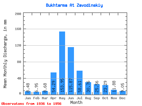
| Statistic | Jan | Feb | Mar | Apr | May | Jun | Jul | Aug | Sep | Oct | Nov | Dec | Annual |
|---|---|---|---|---|---|---|---|---|---|---|---|---|---|
| Mean | 8.48 | 7.01 | 8.68 | 54.29 | 153.92 | 115.87 | 58.60 | 30.75 | 25.56 | 23.29 | 11.88 | 9.05 | 480.06 |
| Standard Deviation | 1.47 | 1.18 | 1.07 | 23.21 | 36.47 | 46.34 | 23.50 | 8.74 | 10.37 | 9.25 | 3.66 | 2.08 | 98.95 |
| Min | 5.84 | 4.01 | 7.17 | 17.74 | 88.97 | 33.40 | 21.57 | 17.90 | 11.32 | 16.39 | 7.51 | 7.21 | 280.14 |
| Max | 11.27 | 9.25 | 10.64 | 85.24 | 217.47 | 200.05 | 100.83 | 48.71 | 53.58 | 47.81 | 18.44 | 14.31 | 586.95 |
| Coefficient of Variation | 0.17 | 0.17 | 0.12 | 0.43 | 0.24 | 0.40 | 0.40 | 0.28 | 0.41 | 0.40 | 0.31 | 0.23 | 0.21 |
 Return to R-Arctic Net Home Page