|
|
|||||||||||||||||
| Point ID: 8571 | Downloads | Plots | Site Data | Code: 11122 |
|
|
|||||||||||||||||
| Download | |
|---|---|
| Site Descriptor Information | Site Time Series Data |
| Link to all available data | |
| View: | Time Series | All |
| Units: | mm |
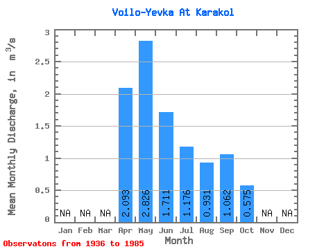
| Statistic | Jan | Feb | Mar | Apr | May | Jun | Jul | Aug | Sep | Oct | Nov | Dec | Annual |
|---|---|---|---|---|---|---|---|---|---|---|---|---|---|
| Mean | 2.09 | 2.83 | 1.71 | 1.18 | 0.93 | 1.06 | 0.57 | ||||||
| Standard Deviation | 1.15 | 1.95 | 1.73 | 1.07 | 0.83 | 0.93 | 0.51 | ||||||
| Min | 0.47 | 0.55 | 0.22 | 0.04 | 0.04 | 0.08 | 0.12 | ||||||
| Max | 4.06 | 8.55 | 8.43 | 4.93 | 2.65 | 2.95 | 1.02 | ||||||
| Coefficient of Variation | 0.55 | 0.69 | 1.01 | 0.91 | 0.89 | 0.87 | 0.89 |
 Return to R-Arctic Net Home Page