|
|
|||||||||||||||||
| Point ID: 8571 | Downloads | Plots | Site Data | Code: 11122 |
|
|
|||||||||||||||||
| Download | |
|---|---|
| Site Descriptor Information | Site Time Series Data |
| Link to all available data | |
| View: | Time Series | All |
| Units: | m3/s |
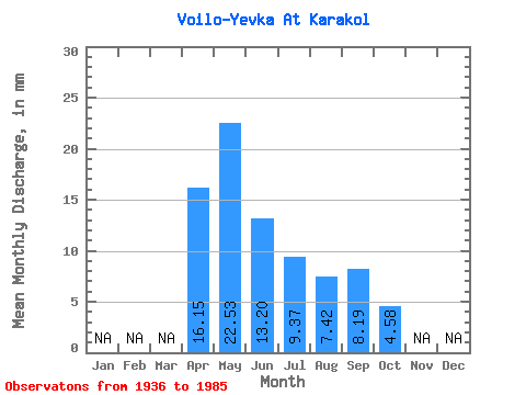
| Statistic | Jan | Feb | Mar | Apr | May | Jun | Jul | Aug | Sep | Oct | Nov | Dec | Annual |
|---|---|---|---|---|---|---|---|---|---|---|---|---|---|
| Mean | 16.15 | 22.53 | 13.20 | 9.38 | 7.42 | 8.19 | 4.58 | ||||||
| Standard Deviation | 8.88 | 15.52 | 13.35 | 8.56 | 6.58 | 7.15 | 4.10 | ||||||
| Min | 3.63 | 4.38 | 1.70 | 0.31 | 0.29 | 0.63 | 0.96 | ||||||
| Max | 31.32 | 68.15 | 65.04 | 39.30 | 21.13 | 22.76 | 8.13 | ||||||
| Coefficient of Variation | 0.55 | 0.69 | 1.01 | 0.91 | 0.89 | 0.87 | 0.89 |
 Return to R-Arctic Net Home Page