|
|
|||||||||||||||||
| Point ID: 8570 | Downloads | Plots | Site Data | Code: 11116 |
|
|
|||||||||||||||||
| Download | |
|---|---|
| Site Descriptor Information | Site Time Series Data |
| Link to all available data | |
| View: | Time Series | All |
| Units: | mm |
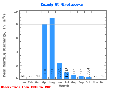
| Statistic | Jan | Feb | Mar | Apr | May | Jun | Jul | Aug | Sep | Oct | Nov | Dec | Annual |
|---|---|---|---|---|---|---|---|---|---|---|---|---|---|
| Mean | 8.05 | 8.94 | 2.36 | 1.01 | 0.69 | 0.51 | 0.36 | ||||||
| Standard Deviation | 5.77 | 11.81 | 1.26 | 0.82 | 1.14 | 0.62 | 0.24 | ||||||
| Min | 1.67 | 0.61 | 0.24 | -0.06 | -0.03 | -0.37 | 0.08 | ||||||
| Max | 23.00 | 69.70 | 5.58 | 4.11 | 6.46 | 2.45 | 0.73 | ||||||
| Coefficient of Variation | 0.72 | 1.32 | 0.53 | 0.81 | 1.67 | 1.23 | 0.67 |
 Return to R-Arctic Net Home Page