|
|
|||||||||||||||||
| Point ID: 8570 | Downloads | Plots | Site Data | Code: 11116 |
|
|
|||||||||||||||||
| Download | |
|---|---|
| Site Descriptor Information | Site Time Series Data |
| Link to all available data | |
| View: | Time Series | All |
| Units: | m3/s |
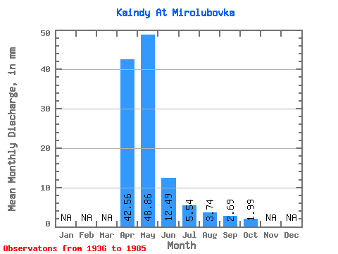
| Statistic | Jan | Feb | Mar | Apr | May | Jun | Jul | Aug | Sep | Oct | Nov | Dec | Annual |
|---|---|---|---|---|---|---|---|---|---|---|---|---|---|
| Mean | 42.56 | 48.85 | 12.49 | 5.54 | 3.74 | 2.69 | 1.99 | ||||||
| Standard Deviation | 30.50 | 64.57 | 6.67 | 4.51 | 6.23 | 3.31 | 1.34 | ||||||
| Min | 8.84 | 3.33 | 1.27 | -0.31 | -0.14 | -1.96 | 0.43 | ||||||
| Max | 121.67 | 380.93 | 29.52 | 22.47 | 35.31 | 12.96 | 3.99 | ||||||
| Coefficient of Variation | 0.72 | 1.32 | 0.53 | 0.81 | 1.67 | 1.23 | 0.67 |
 Return to R-Arctic Net Home Page