|
|
|||||||||||||||||
| Point ID: 8568 | Downloads | Plots | Site Data | Code: 11112 |
|
|
|||||||||||||||||
| Download | |
|---|---|
| Site Descriptor Information | Site Time Series Data |
| Link to all available data | |
| View: | Time Series | All |
| Units: | mm |
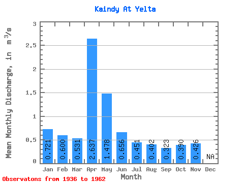
| Statistic | Jan | Feb | Mar | Apr | May | Jun | Jul | Aug | Sep | Oct | Nov | Dec | Annual |
|---|---|---|---|---|---|---|---|---|---|---|---|---|---|
| Mean | 0.72 | 0.60 | 0.53 | 2.64 | 1.48 | 0.66 | 0.45 | 0.40 | 0.32 | 0.39 | 0.43 | ||
| Standard Deviation | 3.32 | 1.30 | 0.44 | 0.32 | 0.29 | 0.15 | 0.12 | 0.13 | |||||
| Min | 0.72 | 0.60 | 0.53 | 0.29 | 0.19 | 0.16 | 0.07 | 0.10 | 0.14 | 0.30 | 0.33 | ||
| Max | 0.72 | 0.60 | 0.53 | 11.40 | 4.55 | 2.04 | 1.36 | 1.24 | 0.57 | 0.53 | 0.52 | ||
| Coefficient of Variation | 1.26 | 0.88 | 0.67 | 0.72 | 0.71 | 0.48 | 0.32 | 0.32 |
 Return to R-Arctic Net Home Page