|
|
|||||||||||||||||
| Point ID: 8568 | Downloads | Plots | Site Data | Code: 11112 |
|
|
|||||||||||||||||
| Download | |
|---|---|
| Site Descriptor Information | Site Time Series Data |
| Link to all available data | |
| View: | Time Series | All |
| Units: | m3/s |
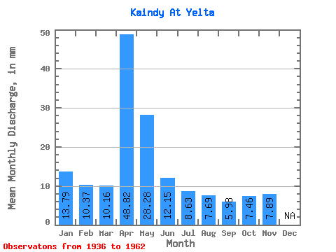
| Statistic | Jan | Feb | Mar | Apr | May | Jun | Jul | Aug | Sep | Oct | Nov | Dec | Annual |
|---|---|---|---|---|---|---|---|---|---|---|---|---|---|
| Mean | 13.78 | 10.46 | 10.15 | 48.82 | 28.26 | 12.15 | 8.62 | 7.68 | 5.98 | 7.47 | 7.88 | ||
| Standard Deviation | 61.54 | 24.96 | 8.10 | 6.20 | 5.47 | 2.85 | 2.35 | 2.49 | |||||
| Min | 13.78 | 10.46 | 10.15 | 5.38 | 3.65 | 2.97 | 1.44 | 1.91 | 2.60 | 5.74 | 6.12 | ||
| Max | 13.78 | 10.46 | 10.15 | 211.06 | 87.05 | 37.78 | 26.03 | 23.73 | 10.56 | 10.15 | 9.64 | ||
| Coefficient of Variation | 1.26 | 0.88 | 0.67 | 0.72 | 0.71 | 0.48 | 0.32 | 0.32 |
 Return to R-Arctic Net Home Page