|
|
|||||||||||||||||
| Point ID: 8566 | Downloads | Plots | Site Data | Code: 11106 |
|
|
|||||||||||||||||
| Download | |
|---|---|
| Site Descriptor Information | Site Time Series Data |
| Link to all available data | |
| View: | Time Series | All |
| Units: | mm |
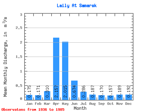
| Statistic | Jan | Feb | Mar | Apr | May | Jun | Jul | Aug | Sep | Oct | Nov | Dec | Annual |
|---|---|---|---|---|---|---|---|---|---|---|---|---|---|
| Mean | 0.17 | 0.17 | 0.31 | 2.16 | 2.02 | 0.67 | 0.29 | 0.19 | 0.17 | 0.16 | 0.19 | 0.19 | 0.57 |
| Standard Deviation | 0.13 | 0.12 | 0.40 | 1.36 | 1.42 | 0.47 | 0.18 | 0.11 | 0.10 | 0.07 | 0.12 | 0.14 | 0.28 |
| Min | 0.01 | 0.01 | 0.06 | 0.24 | 0.13 | 0.05 | 0.00 | 0.00 | 0.00 | 0.04 | 0.04 | 0.04 | 0.07 |
| Max | 0.40 | 0.48 | 1.71 | 5.55 | 5.97 | 2.27 | 0.79 | 0.53 | 0.47 | 0.37 | 0.50 | 0.58 | 1.10 |
| Coefficient of Variation | 0.72 | 0.72 | 1.30 | 0.63 | 0.71 | 0.69 | 0.64 | 0.59 | 0.56 | 0.44 | 0.66 | 0.75 | 0.49 |
 Return to R-Arctic Net Home Page