|
|
|||||||||||||||||
| Point ID: 8566 | Downloads | Plots | Site Data | Code: 11106 |
|
|
|||||||||||||||||
| Download | |
|---|---|
| Site Descriptor Information | Site Time Series Data |
| Link to all available data | |
| View: | Time Series | All |
| Units: | m3/s |
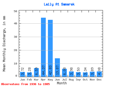
| Statistic | Jan | Feb | Mar | Apr | May | Jun | Jul | Aug | Sep | Oct | Nov | Dec | Annual |
|---|---|---|---|---|---|---|---|---|---|---|---|---|---|
| Mean | 3.72 | 3.31 | 6.58 | 44.38 | 42.83 | 13.86 | 6.07 | 3.98 | 3.49 | 3.34 | 3.88 | 4.08 | 143.63 |
| Standard Deviation | 2.70 | 2.40 | 8.56 | 27.98 | 30.27 | 9.58 | 3.89 | 2.37 | 1.97 | 1.48 | 2.55 | 3.05 | 70.05 |
| Min | 0.21 | 0.19 | 1.25 | 4.94 | 2.76 | 1.05 | 0.00 | 0.00 | 0.00 | 0.74 | 0.84 | 0.83 | 18.70 |
| Max | 8.50 | 9.29 | 36.34 | 114.17 | 126.89 | 46.70 | 16.79 | 11.28 | 9.68 | 7.86 | 10.29 | 12.33 | 276.15 |
| Coefficient of Variation | 0.72 | 0.72 | 1.30 | 0.63 | 0.71 | 0.69 | 0.64 | 0.59 | 0.56 | 0.44 | 0.66 | 0.75 | 0.49 |
 Return to R-Arctic Net Home Page