|
|
|||||||||||||||||
| Point ID: 8556 | Downloads | Plots | Site Data | Code: 11092 |
|
|
|||||||||||||||||
| Download | |
|---|---|
| Site Descriptor Information | Site Time Series Data |
| Link to all available data | |
| View: | Time Series | All |
| Units: | mm |
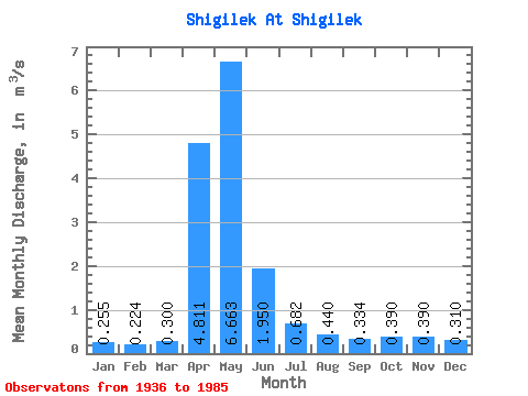
| Statistic | Jan | Feb | Mar | Apr | May | Jun | Jul | Aug | Sep | Oct | Nov | Dec | Annual |
|---|---|---|---|---|---|---|---|---|---|---|---|---|---|
| Mean | 0.26 | 0.22 | 0.30 | 4.81 | 6.66 | 1.95 | 0.68 | 0.44 | 0.33 | 0.39 | 0.39 | 0.31 | 1.31 |
| Standard Deviation | 0.08 | 0.06 | 0.19 | 2.91 | 4.69 | 1.55 | 0.54 | 0.48 | 0.23 | 0.24 | 0.26 | 0.12 | 0.64 |
| Min | 0.15 | 0.10 | 0.09 | 0.56 | 1.24 | 0.21 | 0.09 | 0.08 | 0.08 | 0.08 | 0.11 | 0.12 | 0.45 |
| Max | 0.53 | 0.42 | 1.07 | 12.50 | 22.60 | 6.71 | 2.32 | 2.87 | 1.29 | 1.26 | 1.19 | 0.59 | 2.62 |
| Coefficient of Variation | 0.32 | 0.28 | 0.62 | 0.60 | 0.70 | 0.80 | 0.80 | 1.10 | 0.70 | 0.63 | 0.66 | 0.39 | 0.49 |
 Return to R-Arctic Net Home Page