|
|
|||||||||||||||||
| Point ID: 8556 | Downloads | Plots | Site Data | Code: 11092 |
|
|
|||||||||||||||||
| Download | |
|---|---|
| Site Descriptor Information | Site Time Series Data |
| Link to all available data | |
| View: | Time Series | All |
| Units: | m3/s |
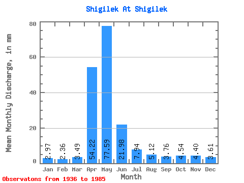
| Statistic | Jan | Feb | Mar | Apr | May | Jun | Jul | Aug | Sep | Oct | Nov | Dec | Annual |
|---|---|---|---|---|---|---|---|---|---|---|---|---|---|
| Mean | 2.97 | 2.37 | 3.49 | 54.21 | 77.58 | 21.98 | 7.95 | 5.12 | 3.76 | 4.54 | 4.39 | 3.61 | 179.79 |
| Standard Deviation | 0.96 | 0.67 | 2.16 | 32.77 | 54.61 | 17.51 | 6.33 | 5.63 | 2.64 | 2.85 | 2.88 | 1.40 | 88.07 |
| Min | 1.75 | 1.02 | 1.06 | 6.32 | 14.44 | 2.37 | 0.99 | 0.89 | 0.88 | 0.90 | 1.24 | 1.40 | 61.87 |
| Max | 6.17 | 4.46 | 12.46 | 140.87 | 263.14 | 75.63 | 27.01 | 33.42 | 14.54 | 14.68 | 13.41 | 6.87 | 359.64 |
| Coefficient of Variation | 0.32 | 0.28 | 0.62 | 0.60 | 0.70 | 0.80 | 0.80 | 1.10 | 0.70 | 0.63 | 0.66 | 0.39 | 0.49 |
 Return to R-Arctic Net Home Page