|
|
|||||||||||||||||
| Point ID: 8554 | Downloads | Plots | Site Data | Code: 11084 |
|
|
|||||||||||||||||
| Download | |
|---|---|
| Site Descriptor Information | Site Time Series Data |
| Link to all available data | |
| View: | Time Series | All |
| Units: | mm |
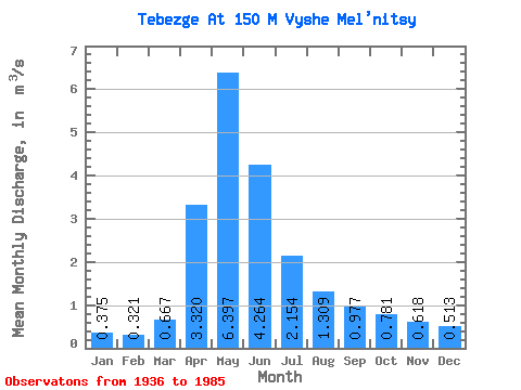
| Statistic | Jan | Feb | Mar | Apr | May | Jun | Jul | Aug | Sep | Oct | Nov | Dec | Annual |
|---|---|---|---|---|---|---|---|---|---|---|---|---|---|
| Mean | 0.38 | 0.32 | 0.67 | 3.32 | 6.40 | 4.26 | 2.15 | 1.31 | 0.98 | 0.78 | 0.62 | 0.51 | 2.00 |
| Standard Deviation | 0.15 | 0.12 | 1.02 | 3.72 | 4.44 | 2.61 | 1.26 | 0.71 | 0.52 | 0.41 | 0.30 | 0.19 | 1.06 |
| Min | 0.06 | 0.10 | 0.24 | 0.35 | 1.07 | 0.83 | 0.37 | 0.29 | 0.26 | 0.24 | 0.28 | 0.21 | 0.79 |
| Max | 0.79 | 0.58 | 5.57 | 18.00 | 16.90 | 11.00 | 5.70 | 3.05 | 2.56 | 1.96 | 1.79 | 1.18 | 3.83 |
| Coefficient of Variation | 0.41 | 0.37 | 1.52 | 1.12 | 0.69 | 0.61 | 0.58 | 0.54 | 0.53 | 0.52 | 0.48 | 0.36 | 0.53 |
 Return to R-Arctic Net Home Page