|
|
|||||||||||||||||
| Point ID: 8554 | Downloads | Plots | Site Data | Code: 11084 |
|
|
|||||||||||||||||
| Download | |
|---|---|
| Site Descriptor Information | Site Time Series Data |
| Link to all available data | |
| View: | Time Series | All |
| Units: | m3/s |
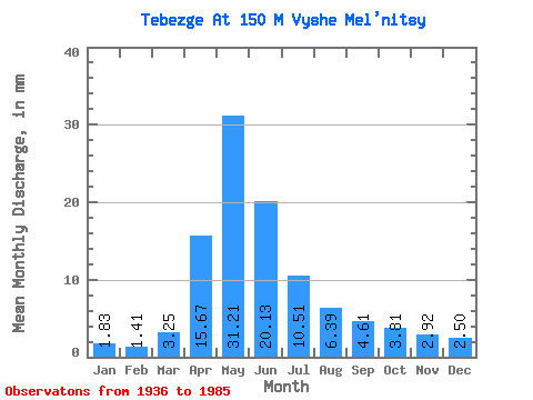
| Statistic | Jan | Feb | Mar | Apr | May | Jun | Jul | Aug | Sep | Oct | Nov | Dec | Annual |
|---|---|---|---|---|---|---|---|---|---|---|---|---|---|
| Mean | 1.83 | 1.43 | 3.26 | 15.67 | 31.20 | 20.13 | 10.51 | 6.38 | 4.62 | 3.81 | 2.92 | 2.50 | 114.70 |
| Standard Deviation | 0.75 | 0.53 | 4.96 | 17.58 | 21.65 | 12.31 | 6.13 | 3.46 | 2.45 | 2.00 | 1.41 | 0.91 | 60.96 |
| Min | 0.31 | 0.44 | 1.17 | 1.66 | 5.22 | 3.92 | 1.81 | 1.42 | 1.23 | 1.17 | 1.32 | 1.02 | 45.32 |
| Max | 3.86 | 2.58 | 27.17 | 84.98 | 82.44 | 51.93 | 27.80 | 14.88 | 12.09 | 9.56 | 8.45 | 5.76 | 219.96 |
| Coefficient of Variation | 0.41 | 0.37 | 1.52 | 1.12 | 0.69 | 0.61 | 0.58 | 0.54 | 0.53 | 0.52 | 0.48 | 0.36 | 0.53 |
 Return to R-Arctic Net Home Page