|
|
|||||||||||||||||
| Point ID: 855 | Downloads | Plots | Site Data | Code: 07EA004 |
|
|
|||||||||||||||||
| Download | |
|---|---|
| Site Descriptor Information | Site Time Series Data |
| Link to all available data | |
| View: | Time Series | All |
| Units: | mm |
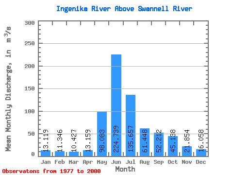
| Statistic | Jan | Feb | Mar | Apr | May | Jun | Jul | Aug | Sep | Oct | Nov | Dec | Annual |
|---|---|---|---|---|---|---|---|---|---|---|---|---|---|
| Mean | 13.12 | 11.35 | 10.43 | 13.16 | 98.08 | 224.74 | 135.66 | 61.45 | 52.21 | 45.14 | 21.85 | 16.06 | 58.70 |
| Standard Deviation | 2.11 | 1.98 | 1.51 | 3.34 | 47.39 | 50.97 | 41.88 | 15.88 | 14.78 | 12.28 | 4.34 | 3.28 | 6.86 |
| Min | 9.73 | 7.69 | 6.36 | 7.47 | 38.00 | 134.00 | 66.90 | 35.30 | 30.90 | 20.10 | 13.40 | 11.20 | 42.50 |
| Max | 18.40 | 16.70 | 13.30 | 23.30 | 198.00 | 321.00 | 244.00 | 98.30 | 77.70 | 67.40 | 28.10 | 22.50 | 73.33 |
| Coefficient of Variation | 0.16 | 0.17 | 0.14 | 0.25 | 0.48 | 0.23 | 0.31 | 0.26 | 0.28 | 0.27 | 0.20 | 0.20 | 0.12 |
 Return to R-Arctic Net Home Page