|
|
|||||||||||||||||
| Point ID: 855 | Downloads | Plots | Site Data | Code: 07EA004 |
|
|
|||||||||||||||||
| Download | |
|---|---|
| Site Descriptor Information | Site Time Series Data |
| Link to all available data | |
| View: | Time Series | All |
| Units: | m3/s |
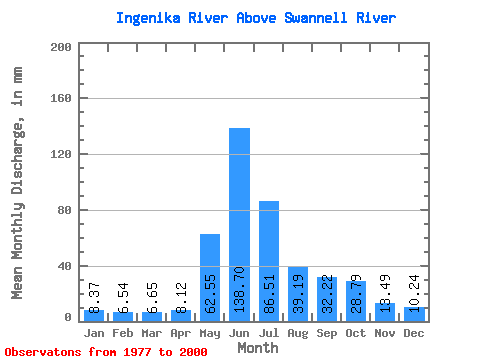
| Statistic | Jan | Feb | Mar | Apr | May | Jun | Jul | Aug | Sep | Oct | Nov | Dec | Annual |
|---|---|---|---|---|---|---|---|---|---|---|---|---|---|
| Mean | 8.37 | 6.59 | 6.65 | 8.12 | 62.54 | 138.70 | 86.50 | 39.18 | 32.22 | 28.78 | 13.49 | 10.24 | 441.05 |
| Standard Deviation | 1.34 | 1.15 | 0.96 | 2.06 | 30.21 | 31.45 | 26.70 | 10.13 | 9.12 | 7.83 | 2.68 | 2.09 | 51.57 |
| Min | 6.20 | 4.47 | 4.05 | 4.61 | 24.23 | 82.70 | 42.66 | 22.51 | 19.07 | 12.82 | 8.27 | 7.14 | 319.37 |
| Max | 11.73 | 9.70 | 8.48 | 14.38 | 126.25 | 198.10 | 155.58 | 62.68 | 47.95 | 42.98 | 17.34 | 14.35 | 551.05 |
| Coefficient of Variation | 0.16 | 0.17 | 0.14 | 0.25 | 0.48 | 0.23 | 0.31 | 0.26 | 0.28 | 0.27 | 0.20 | 0.20 | 0.12 |
 Return to R-Arctic Net Home Page