|
|
|||||||||||||||||
| Point ID: 8546 | Downloads | Plots | Site Data | Code: 11071 |
|
|
|||||||||||||||||
| Download | |
|---|---|
| Site Descriptor Information | Site Time Series Data |
| Link to all available data | |
| View: | Time Series | All |
| Units: | mm |
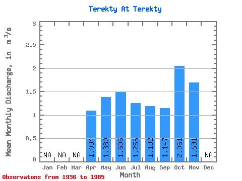
| Statistic | Jan | Feb | Mar | Apr | May | Jun | Jul | Aug | Sep | Oct | Nov | Dec | Annual |
|---|---|---|---|---|---|---|---|---|---|---|---|---|---|
| Mean | 1.09 | 1.38 | 1.50 | 1.26 | 1.19 | 1.15 | 2.05 | 1.69 | |||||
| Standard Deviation | 1.42 | 0.78 | 0.98 | 1.03 | 1.19 | 1.61 | |||||||
| Min | 0.19 | 0.49 | 0.37 | 0.35 | 0.24 | 0.12 | 2.05 | 1.69 | |||||
| Max | 2.73 | 3.60 | 4.10 | 3.92 | 4.22 | 3.00 | 2.05 | 1.69 | |||||
| Coefficient of Variation | 1.30 | 0.57 | 0.65 | 0.82 | 1.00 | 1.40 |
 Return to R-Arctic Net Home Page