|
|
|||||||||||||||||
| Point ID: 8546 | Downloads | Plots | Site Data | Code: 11071 |
|
|
|||||||||||||||||
| Download | |
|---|---|
| Site Descriptor Information | Site Time Series Data |
| Link to all available data | |
| View: | Time Series | All |
| Units: | m3/s |
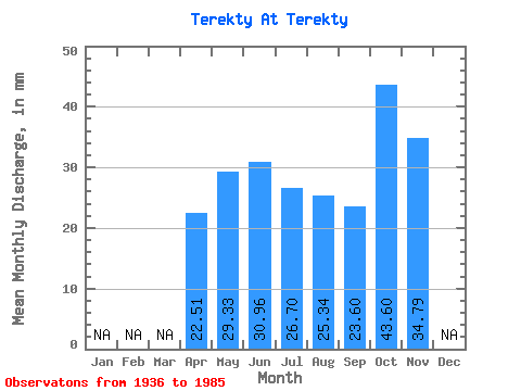
| Statistic | Jan | Feb | Mar | Apr | May | Jun | Jul | Aug | Sep | Oct | Nov | Dec | Annual |
|---|---|---|---|---|---|---|---|---|---|---|---|---|---|
| Mean | 22.50 | 29.33 | 30.95 | 26.69 | 25.33 | 23.60 | 43.58 | 34.78 | |||||
| Standard Deviation | 29.21 | 16.60 | 20.15 | 21.95 | 25.32 | 33.08 | |||||||
| Min | 3.92 | 10.41 | 7.62 | 7.44 | 5.10 | 2.48 | 43.58 | 34.78 | |||||
| Max | 56.17 | 76.51 | 84.34 | 83.32 | 89.69 | 61.71 | 43.58 | 34.78 | |||||
| Coefficient of Variation | 1.30 | 0.57 | 0.65 | 0.82 | 1.00 | 1.40 |
 Return to R-Arctic Net Home Page