|
|
|||||||||||||||||
| Point ID: 8545 | Downloads | Plots | Site Data | Code: 11069 |
|
|
|||||||||||||||||
| Download | |
|---|---|
| Site Descriptor Information | Site Time Series Data |
| Link to all available data | |
| View: | Time Series | All |
| Units: | mm |
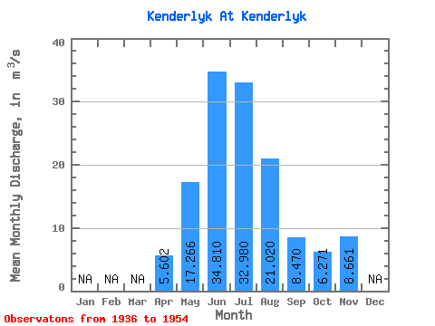
| Statistic | Jan | Feb | Mar | Apr | May | Jun | Jul | Aug | Sep | Oct | Nov | Dec | Annual |
|---|---|---|---|---|---|---|---|---|---|---|---|---|---|
| Mean | 5.60 | 17.27 | 34.81 | 32.98 | 21.02 | 8.47 | 6.27 | 8.66 | |||||
| Standard Deviation | 4.16 | 9.15 | 29.19 | 26.63 | 15.41 | 5.22 | 3.11 | ||||||
| Min | 1.97 | 8.66 | 11.20 | 12.40 | 9.40 | 2.72 | 2.03 | 8.66 | |||||
| Max | 12.40 | 39.60 | 111.00 | 103.00 | 60.90 | 15.10 | 8.69 | 8.66 | |||||
| Coefficient of Variation | 0.74 | 0.53 | 0.84 | 0.81 | 0.73 | 0.62 | 0.50 |
 Return to R-Arctic Net Home Page