|
|
|||||||||||||||||
| Point ID: 8545 | Downloads | Plots | Site Data | Code: 11069 |
|
|
|||||||||||||||||
| Download | |
|---|---|
| Site Descriptor Information | Site Time Series Data |
| Link to all available data | |
| View: | Time Series | All |
| Units: | m3/s |
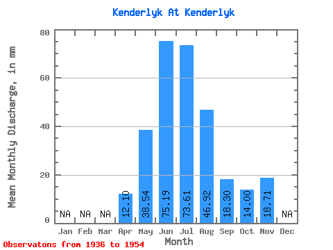
| Statistic | Jan | Feb | Mar | Apr | May | Jun | Jul | Aug | Sep | Oct | Nov | Dec | Annual |
|---|---|---|---|---|---|---|---|---|---|---|---|---|---|
| Mean | 12.10 | 38.53 | 75.19 | 73.60 | 46.91 | 18.30 | 13.99 | 18.71 | |||||
| Standard Deviation | 8.99 | 20.42 | 63.05 | 59.43 | 34.38 | 11.28 | 6.95 | ||||||
| Min | 4.26 | 19.33 | 24.19 | 27.67 | 20.98 | 5.88 | 4.53 | 18.71 | |||||
| Max | 26.78 | 88.37 | 239.76 | 229.86 | 135.91 | 32.62 | 19.39 | 18.71 | |||||
| Coefficient of Variation | 0.74 | 0.53 | 0.84 | 0.81 | 0.73 | 0.62 | 0.50 |
 Return to R-Arctic Net Home Page