|
|
|||||||||||||||||
| Point ID: 8519 | Downloads | Plots | Site Data | Code: 10543 |
|
|
|||||||||||||||||
| Download | |
|---|---|
| Site Descriptor Information | Site Time Series Data |
| Link to all available data | |
| View: | Time Series | All |
| Units: | mm |
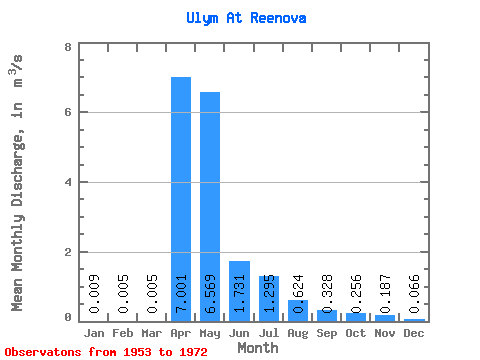
| Statistic | Jan | Feb | Mar | Apr | May | Jun | Jul | Aug | Sep | Oct | Nov | Dec | Annual |
|---|---|---|---|---|---|---|---|---|---|---|---|---|---|
| Mean | 0.01 | 0.01 | 0.01 | 7.00 | 6.57 | 1.73 | 1.29 | 0.62 | 0.33 | 0.26 | 0.19 | 0.07 | 1.51 |
| Standard Deviation | 0.02 | 0.01 | 0.01 | 5.00 | 5.33 | 1.84 | 3.64 | 1.57 | 0.81 | 0.60 | 0.36 | 0.16 | 1.13 |
| Min | 0.00 | 0.00 | 0.00 | 0.64 | 0.07 | 0.00 | 0.00 | 0.00 | 0.00 | 0.00 | 0.00 | 0.00 | 0.06 |
| Max | 0.09 | 0.05 | 0.05 | 22.10 | 19.10 | 7.04 | 16.50 | 6.93 | 3.56 | 2.62 | 1.59 | 0.72 | 3.71 |
| Coefficient of Variation | 2.43 | 2.56 | 2.48 | 0.71 | 0.81 | 1.06 | 2.81 | 2.52 | 2.47 | 2.33 | 1.92 | 2.46 | 0.75 |
 Return to R-Arctic Net Home Page