|
|
|||||||||||||||||
| Point ID: 8519 | Downloads | Plots | Site Data | Code: 10543 |
|
|
|||||||||||||||||
| Download | |
|---|---|
| Site Descriptor Information | Site Time Series Data |
| Link to all available data | |
| View: | Time Series | All |
| Units: | m3/s |
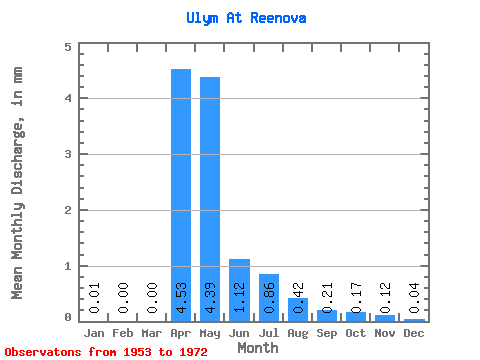
| Statistic | Jan | Feb | Mar | Apr | May | Jun | Jul | Aug | Sep | Oct | Nov | Dec | Annual |
|---|---|---|---|---|---|---|---|---|---|---|---|---|---|
| Mean | 0.01 | 0.00 | 0.00 | 4.53 | 4.39 | 1.12 | 0.86 | 0.42 | 0.21 | 0.17 | 0.12 | 0.04 | 11.86 |
| Standard Deviation | 0.01 | 0.01 | 0.01 | 3.23 | 3.56 | 1.19 | 2.43 | 1.05 | 0.52 | 0.40 | 0.23 | 0.11 | 8.89 |
| Min | 0.00 | 0.00 | 0.00 | 0.41 | 0.05 | 0.00 | 0.00 | 0.00 | 0.00 | 0.00 | 0.00 | 0.00 | 0.48 |
| Max | 0.06 | 0.03 | 0.03 | 14.29 | 12.76 | 4.55 | 11.02 | 4.63 | 2.30 | 1.75 | 1.03 | 0.48 | 29.22 |
| Coefficient of Variation | 2.43 | 2.56 | 2.48 | 0.71 | 0.81 | 1.06 | 2.81 | 2.52 | 2.47 | 2.33 | 1.92 | 2.46 | 0.75 |
 Return to R-Arctic Net Home Page