|
|
|||||||||||||||||
| Point ID: 8503 | Downloads | Plots | Site Data | Code: 10459 |
|
|
|||||||||||||||||
| Download | |
|---|---|
| Site Descriptor Information | Site Time Series Data |
| Link to all available data | |
| View: | Time Series | All |
| Units: | mm |
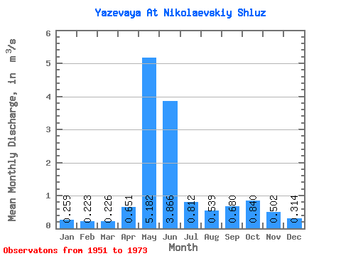
| Statistic | Jan | Feb | Mar | Apr | May | Jun | Jul | Aug | Sep | Oct | Nov | Dec | Annual |
|---|---|---|---|---|---|---|---|---|---|---|---|---|---|
| Mean | 0.26 | 0.22 | 0.23 | 0.65 | 5.18 | 3.87 | 0.81 | 0.54 | 0.68 | 0.84 | 0.50 | 0.31 | 1.17 |
| Standard Deviation | 0.11 | 0.08 | 0.08 | 0.42 | 1.79 | 2.58 | 0.36 | 0.25 | 0.31 | 0.41 | 0.28 | 0.15 | 0.39 |
| Min | 0.12 | 0.09 | 0.10 | 0.16 | 1.90 | 0.96 | 0.37 | 0.26 | 0.26 | 0.29 | 0.15 | 0.11 | 0.60 |
| Max | 0.51 | 0.40 | 0.37 | 1.69 | 9.38 | 11.00 | 1.63 | 1.18 | 1.36 | 1.80 | 1.26 | 0.69 | 1.88 |
| Coefficient of Variation | 0.42 | 0.34 | 0.34 | 0.64 | 0.35 | 0.67 | 0.44 | 0.46 | 0.46 | 0.49 | 0.57 | 0.47 | 0.33 |
 Return to R-Arctic Net Home Page