|
|
|||||||||||||||||
| Point ID: 8503 | Downloads | Plots | Site Data | Code: 10459 |
|
|
|||||||||||||||||
| Download | |
|---|---|
| Site Descriptor Information | Site Time Series Data |
| Link to all available data | |
| View: | Time Series | All |
| Units: | m3/s |
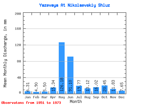
| Statistic | Jan | Feb | Mar | Apr | May | Jun | Jul | Aug | Sep | Oct | Nov | Dec | Annual |
|---|---|---|---|---|---|---|---|---|---|---|---|---|---|
| Mean | 6.31 | 4.94 | 5.49 | 15.35 | 126.15 | 91.09 | 19.77 | 13.12 | 16.02 | 20.44 | 11.82 | 7.64 | 336.94 |
| Standard Deviation | 2.63 | 1.69 | 1.85 | 9.81 | 43.69 | 60.76 | 8.74 | 6.04 | 7.33 | 10.00 | 6.69 | 3.61 | 110.57 |
| Min | 2.92 | 2.04 | 2.36 | 3.77 | 46.26 | 22.62 | 9.01 | 6.33 | 6.13 | 7.06 | 3.54 | 2.68 | 172.62 |
| Max | 12.42 | 8.87 | 9.01 | 39.82 | 228.36 | 259.20 | 39.68 | 28.73 | 32.05 | 43.82 | 29.69 | 16.80 | 539.39 |
| Coefficient of Variation | 0.42 | 0.34 | 0.34 | 0.64 | 0.35 | 0.67 | 0.44 | 0.46 | 0.46 | 0.49 | 0.57 | 0.47 | 0.33 |
 Return to R-Arctic Net Home Page