|
|
|||||||||||||||||
| Point ID: 85 | Downloads | Plots | Site Data | Code: 05AD004 |
|
|
|||||||||||||||||
| Download | |
|---|---|
| Site Descriptor Information | Site Time Series Data |
| Link to all available data | |
| View: | Time Series | All |
| Units: | mm |
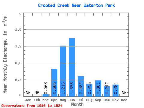
| Statistic | Jan | Feb | Mar | Apr | May | Jun | Jul | Aug | Sep | Oct | Nov | Dec | Annual |
|---|---|---|---|---|---|---|---|---|---|---|---|---|---|
| Mean | 0.06 | 0.67 | 1.22 | 1.39 | 0.48 | 0.30 | 0.38 | 0.25 | 0.28 | ||||
| Standard Deviation | 0.07 | 0.26 | 0.69 | 0.90 | 0.49 | 0.40 | 0.76 | 0.26 | |||||
| Min | 0.01 | 0.35 | 0.43 | 0.28 | 0.03 | 0.01 | 0.00 | 0.01 | 0.28 | ||||
| Max | 0.16 | 1.25 | 2.95 | 2.67 | 1.72 | 1.25 | 2.85 | 0.84 | 0.28 | ||||
| Coefficient of Variation | 1.08 | 0.40 | 0.57 | 0.65 | 1.02 | 1.36 | 2.00 | 1.07 |
 Return to R-Arctic Net Home Page