|
|
|||||||||||||||||
| Point ID: 85 | Downloads | Plots | Site Data | Code: 05AD004 |
|
|
|||||||||||||||||
| Download | |
|---|---|
| Site Descriptor Information | Site Time Series Data |
| Link to all available data | |
| View: | Time Series | All |
| Units: | m3/s |
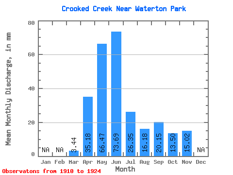
| Statistic | Jan | Feb | Mar | Apr | May | Jun | Jul | Aug | Sep | Oct | Nov | Dec | Annual |
|---|---|---|---|---|---|---|---|---|---|---|---|---|---|
| Mean | 3.42 | 35.16 | 66.48 | 73.69 | 26.34 | 16.20 | 20.15 | 13.48 | 15.02 | ||||
| Standard Deviation | 3.70 | 13.88 | 37.91 | 47.68 | 26.82 | 22.05 | 40.34 | 14.37 | |||||
| Min | 0.27 | 18.51 | 23.28 | 14.92 | 1.80 | 0.33 | 0.05 | 0.55 | 15.02 | ||||
| Max | 8.63 | 66.12 | 161.23 | 141.24 | 94.00 | 68.32 | 150.76 | 46.07 | 15.02 | ||||
| Coefficient of Variation | 1.08 | 0.40 | 0.57 | 0.65 | 1.02 | 1.36 | 2.00 | 1.07 |
 Return to R-Arctic Net Home Page