|
|
|||||||||||||||||
| Point ID: 8489 | Downloads | Plots | Site Data | Code: 10386 |
|
|
|||||||||||||||||
| Download | |
|---|---|
| Site Descriptor Information | Site Time Series Data |
| Link to all available data | |
| View: | Time Series | All |
| Units: | mm |
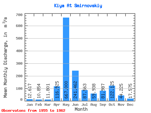
| Statistic | Jan | Feb | Mar | Apr | May | Jun | Jul | Aug | Sep | Oct | Nov | Dec | Annual |
|---|---|---|---|---|---|---|---|---|---|---|---|---|---|
| Mean | 12.62 | 10.85 | 11.80 | 116.92 | 667.00 | 241.46 | 87.56 | 59.94 | 81.99 | 122.12 | 44.23 | 17.57 | 122.84 |
| Standard Deviation | 4.53 | 3.12 | 3.30 | 104.64 | 87.04 | 114.15 | 27.32 | 18.31 | 37.80 | 56.14 | 26.86 | 3.35 | 19.85 |
| Min | 8.99 | 6.59 | 6.86 | 12.20 | 547.00 | 73.70 | 48.50 | 25.70 | 47.50 | 77.70 | 16.60 | 14.40 | 88.58 |
| Max | 22.00 | 14.60 | 16.80 | 337.00 | 798.00 | 391.00 | 147.00 | 79.90 | 141.00 | 218.00 | 97.80 | 22.70 | 148.37 |
| Coefficient of Variation | 0.36 | 0.29 | 0.28 | 0.90 | 0.13 | 0.47 | 0.31 | 0.30 | 0.46 | 0.46 | 0.61 | 0.19 | 0.16 |
 Return to R-Arctic Net Home Page