|
|
|||||||||||||||||
| Point ID: 8489 | Downloads | Plots | Site Data | Code: 10386 |
|
|
|||||||||||||||||
| Download | |
|---|---|
| Site Descriptor Information | Site Time Series Data |
| Link to all available data | |
| View: | Time Series | All |
| Units: | m3/s |
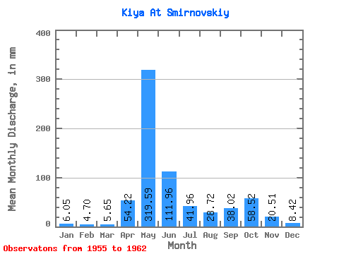
| Statistic | Jan | Feb | Mar | Apr | May | Jun | Jul | Aug | Sep | Oct | Nov | Dec | Annual |
|---|---|---|---|---|---|---|---|---|---|---|---|---|---|
| Mean | 6.04 | 4.74 | 5.65 | 54.22 | 319.54 | 111.96 | 41.95 | 28.71 | 38.02 | 58.51 | 20.51 | 8.42 | 693.53 |
| Standard Deviation | 2.17 | 1.36 | 1.58 | 48.52 | 41.70 | 52.93 | 13.09 | 8.77 | 17.53 | 26.89 | 12.46 | 1.61 | 112.05 |
| Min | 4.31 | 2.88 | 3.29 | 5.66 | 262.05 | 34.17 | 23.23 | 12.31 | 22.02 | 37.22 | 7.70 | 6.90 | 500.08 |
| Max | 10.54 | 6.37 | 8.05 | 156.26 | 382.30 | 181.30 | 70.42 | 38.28 | 65.38 | 104.44 | 45.35 | 10.88 | 837.67 |
| Coefficient of Variation | 0.36 | 0.29 | 0.28 | 0.90 | 0.13 | 0.47 | 0.31 | 0.30 | 0.46 | 0.46 | 0.61 | 0.19 | 0.16 |
 Return to R-Arctic Net Home Page