|
|
|||||||||||||||||
| Point ID: 8479 | Downloads | Plots | Site Data | Code: 10318 |
|
|
|||||||||||||||||
| Download | |
|---|---|
| Site Descriptor Information | Site Time Series Data |
| Link to all available data | |
| View: | Time Series | All |
| Units: | mm |
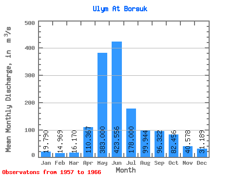
| Statistic | Jan | Feb | Mar | Apr | May | Jun | Jul | Aug | Sep | Oct | Nov | Dec | Annual |
|---|---|---|---|---|---|---|---|---|---|---|---|---|---|
| Mean | 19.79 | 14.97 | 16.17 | 110.37 | 383.00 | 423.56 | 178.00 | 99.94 | 96.32 | 82.46 | 40.58 | 31.19 | 124.75 |
| Standard Deviation | 2.89 | 3.47 | 3.99 | 56.52 | 79.77 | 126.64 | 55.98 | 23.06 | 21.27 | 21.56 | 8.04 | 5.78 | 16.49 |
| Min | 15.50 | 8.19 | 6.73 | 49.50 | 304.00 | 268.00 | 112.00 | 55.30 | 62.70 | 49.90 | 22.10 | 22.80 | 102.17 |
| Max | 25.30 | 18.90 | 20.20 | 231.00 | 520.00 | 640.00 | 266.00 | 134.00 | 131.00 | 126.00 | 48.40 | 43.70 | 151.88 |
| Coefficient of Variation | 0.15 | 0.23 | 0.25 | 0.51 | 0.21 | 0.30 | 0.31 | 0.23 | 0.22 | 0.26 | 0.20 | 0.18 | 0.13 |
 Return to R-Arctic Net Home Page