|
|
|||||||||||||||||
| Point ID: 8479 | Downloads | Plots | Site Data | Code: 10318 |
|
|
|||||||||||||||||
| Download | |
|---|---|
| Site Descriptor Information | Site Time Series Data |
| Link to all available data | |
| View: | Time Series | All |
| Units: | m3/s |
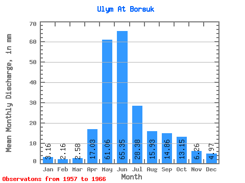
| Statistic | Jan | Feb | Mar | Apr | May | Jun | Jul | Aug | Sep | Oct | Nov | Dec | Annual |
|---|---|---|---|---|---|---|---|---|---|---|---|---|---|
| Mean | 3.15 | 2.17 | 2.58 | 17.03 | 61.05 | 65.35 | 28.37 | 15.93 | 14.86 | 13.14 | 6.26 | 4.97 | 234.36 |
| Standard Deviation | 0.46 | 0.51 | 0.64 | 8.72 | 12.71 | 19.54 | 8.92 | 3.68 | 3.28 | 3.44 | 1.24 | 0.92 | 30.97 |
| Min | 2.47 | 1.19 | 1.07 | 7.64 | 48.46 | 41.35 | 17.85 | 8.81 | 9.67 | 7.95 | 3.41 | 3.63 | 191.94 |
| Max | 4.03 | 2.75 | 3.22 | 35.64 | 82.89 | 98.74 | 42.40 | 21.36 | 20.21 | 20.09 | 7.47 | 6.97 | 285.31 |
| Coefficient of Variation | 0.15 | 0.23 | 0.25 | 0.51 | 0.21 | 0.30 | 0.31 | 0.23 | 0.22 | 0.26 | 0.20 | 0.18 | 0.13 |
 Return to R-Arctic Net Home Page