|
|
|||||||||||||||||
| Point ID: 8454 | Downloads | Plots | Site Data | Code: 10200 |
|
|
|||||||||||||||||
| Download | |
|---|---|
| Site Descriptor Information | Site Time Series Data |
| Link to all available data | |
| View: | Time Series | All |
| Units: | mm |
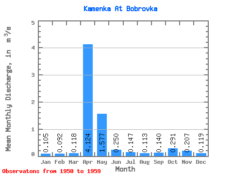
| Statistic | Jan | Feb | Mar | Apr | May | Jun | Jul | Aug | Sep | Oct | Nov | Dec | Annual |
|---|---|---|---|---|---|---|---|---|---|---|---|---|---|
| Mean | 0.10 | 0.09 | 0.12 | 4.12 | 1.58 | 0.25 | 0.15 | 0.11 | 0.14 | 0.29 | 0.21 | 0.12 | 0.61 |
| Standard Deviation | 0.06 | 0.09 | 0.11 | 2.41 | 1.27 | 0.19 | 0.12 | 0.12 | 0.13 | 0.27 | 0.14 | 0.06 | 0.19 |
| Min | 0.01 | 0.00 | 0.00 | 0.59 | 0.33 | 0.09 | 0.04 | 0.02 | 0.02 | 0.04 | 0.03 | 0.02 | 0.29 |
| Max | 0.20 | 0.24 | 0.31 | 8.43 | 4.05 | 0.62 | 0.43 | 0.43 | 0.34 | 0.86 | 0.49 | 0.19 | 0.99 |
| Coefficient of Variation | 0.56 | 0.92 | 0.97 | 0.58 | 0.81 | 0.74 | 0.83 | 1.08 | 0.92 | 0.93 | 0.69 | 0.46 | 0.32 |
 Return to R-Arctic Net Home Page