|
|
|||||||||||||||||
| Point ID: 8454 | Downloads | Plots | Site Data | Code: 10200 |
|
|
|||||||||||||||||
| Download | |
|---|---|
| Site Descriptor Information | Site Time Series Data |
| Link to all available data | |
| View: | Time Series | All |
| Units: | m3/s |
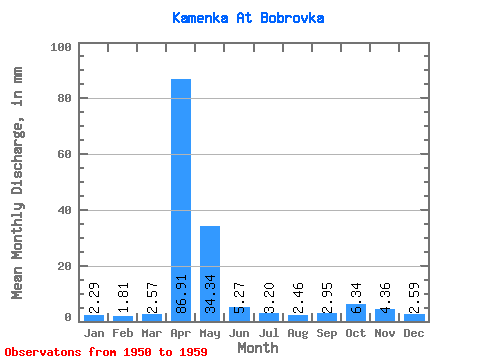
| Statistic | Jan | Feb | Mar | Apr | May | Jun | Jul | Aug | Sep | Oct | Nov | Dec | Annual |
|---|---|---|---|---|---|---|---|---|---|---|---|---|---|
| Mean | 2.30 | 1.83 | 2.56 | 86.91 | 34.34 | 5.27 | 3.19 | 2.46 | 2.95 | 6.34 | 4.35 | 2.60 | 155.73 |
| Standard Deviation | 1.29 | 1.68 | 2.48 | 50.85 | 27.70 | 3.91 | 2.66 | 2.65 | 2.72 | 5.88 | 2.99 | 1.19 | 49.38 |
| Min | 0.30 | 0.00 | 0.00 | 12.43 | 7.18 | 1.88 | 0.81 | 0.50 | 0.46 | 0.91 | 0.59 | 0.41 | 74.45 |
| Max | 4.35 | 4.76 | 6.75 | 177.65 | 88.18 | 13.06 | 9.38 | 9.38 | 7.17 | 18.72 | 10.33 | 4.14 | 253.29 |
| Coefficient of Variation | 0.56 | 0.92 | 0.97 | 0.58 | 0.81 | 0.74 | 0.83 | 1.08 | 0.92 | 0.93 | 0.69 | 0.46 | 0.32 |
 Return to R-Arctic Net Home Page