|
|
|||||||||||||||||
| Point ID: 8450 | Downloads | Plots | Site Data | Code: 10186 |
|
|
|||||||||||||||||
| Download | |
|---|---|
| Site Descriptor Information | Site Time Series Data |
| Link to all available data | |
| View: | Time Series | All |
| Units: | mm |
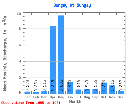
| Statistic | Jan | Feb | Mar | Apr | May | Jun | Jul | Aug | Sep | Oct | Nov | Dec | Annual |
|---|---|---|---|---|---|---|---|---|---|---|---|---|---|
| Mean | 0.28 | 0.25 | 0.32 | 8.35 | 9.61 | 1.47 | 0.52 | 0.55 | 0.57 | 1.38 | 1.02 | 0.36 | 2.03 |
| Standard Deviation | 0.12 | 0.09 | 0.18 | 3.76 | 5.68 | 1.31 | 0.25 | 0.23 | 0.33 | 0.89 | 0.95 | 0.12 | 0.47 |
| Min | 0.13 | 0.12 | 0.10 | 3.25 | 1.28 | 0.37 | 0.25 | 0.16 | 0.17 | 0.31 | 0.17 | 0.13 | 1.10 |
| Max | 0.53 | 0.44 | 0.80 | 15.40 | 20.10 | 5.10 | 1.17 | 0.97 | 1.28 | 2.98 | 3.60 | 0.60 | 2.85 |
| Coefficient of Variation | 0.42 | 0.38 | 0.57 | 0.45 | 0.59 | 0.89 | 0.48 | 0.43 | 0.59 | 0.65 | 0.93 | 0.34 | 0.23 |
 Return to R-Arctic Net Home Page