|
|
|||||||||||||||||
| Point ID: 8450 | Downloads | Plots | Site Data | Code: 10186 |
|
|
|||||||||||||||||
| Download | |
|---|---|
| Site Descriptor Information | Site Time Series Data |
| Link to all available data | |
| View: | Time Series | All |
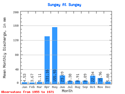
| Units: | m3/s |
| Statistic | Jan | Feb | Mar | Apr | May | Jun | Jul | Aug | Sep | Oct | Nov | Dec | Annual |
|---|---|---|---|---|---|---|---|---|---|---|---|---|---|
| Mean | 4.52 | 3.70 | 5.11 | 131.16 | 155.91 | 23.09 | 8.37 | 8.91 | 8.90 | 22.34 | 15.96 | 5.87 | 388.42 |
| Standard Deviation | 1.90 | 1.39 | 2.89 | 59.01 | 92.12 | 20.57 | 4.05 | 3.80 | 5.22 | 14.51 | 14.92 | 1.99 | 90.55 |
| Min | 2.11 | 1.77 | 1.54 | 51.05 | 20.77 | 5.81 | 4.06 | 2.60 | 2.67 | 5.03 | 2.67 | 2.12 | 210.40 |
| Max | 8.60 | 6.51 | 12.98 | 241.92 | 326.23 | 80.12 | 18.99 | 15.74 | 20.12 | 48.37 | 56.55 | 9.74 | 544.49 |
| Coefficient of Variation | 0.42 | 0.38 | 0.57 | 0.45 | 0.59 | 0.89 | 0.48 | 0.43 | 0.59 | 0.65 | 0.93 | 0.34 | 0.23 |
 Return to R-Arctic Net Home Page