|
|
|||||||||||||||||
| Point ID: 8413 | Downloads | Plots | Site Data | Code: 9551 |
|
|
|||||||||||||||||
| Download | |
|---|---|
| Site Descriptor Information | Site Time Series Data |
| Link to all available data | |
| View: | Time Series | All |
| Units: | mm |
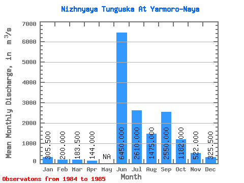
| Statistic | Jan | Feb | Mar | Apr | May | Jun | Jul | Aug | Sep | Oct | Nov | Dec | Annual |
|---|---|---|---|---|---|---|---|---|---|---|---|---|---|
| Mean | 305.50 | 200.00 | 183.50 | 144.00 | 6450.00 | 2610.00 | 1475.00 | 2550.00 | 1182.00 | 522.00 | 325.50 | ||
| Standard Deviation | 166.17 | 79.20 | 89.80 | 353.55 | 155.56 | 49.50 | 1046.52 | 520.43 | 110.31 | 88.39 | |||
| Min | 188.00 | 144.00 | 120.00 | 144.00 | 6200.00 | 2500.00 | 1440.00 | 1810.00 | 814.00 | 444.00 | 263.00 | ||
| Max | 423.00 | 256.00 | 247.00 | 144.00 | 6700.00 | 2720.00 | 1510.00 | 3290.00 | 1550.00 | 600.00 | 388.00 | ||
| Coefficient of Variation | 0.54 | 0.40 | 0.49 | 0.06 | 0.06 | 0.03 | 0.41 | 0.44 | 0.21 | 0.27 |
 Return to R-Arctic Net Home Page