|
|
|||||||||||||||||
| Point ID: 8413 | Downloads | Plots | Site Data | Code: 9551 |
|
|
|||||||||||||||||
| Download | |
|---|---|
| Site Descriptor Information | Site Time Series Data |
| Link to all available data | |
| View: | Time Series | All |
| Units: | m3/s |
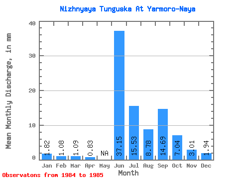
| Statistic | Jan | Feb | Mar | Apr | May | Jun | Jul | Aug | Sep | Oct | Nov | Dec | Annual |
|---|---|---|---|---|---|---|---|---|---|---|---|---|---|
| Mean | 1.82 | 1.08 | 1.09 | 0.83 | 37.15 | 15.53 | 8.78 | 14.69 | 7.03 | 3.01 | 1.94 | ||
| Standard Deviation | 0.99 | 0.43 | 0.53 | 2.04 | 0.93 | 0.29 | 6.03 | 3.10 | 0.64 | 0.53 | |||
| Min | 1.12 | 0.78 | 0.71 | 0.83 | 35.71 | 14.88 | 8.57 | 10.43 | 4.84 | 2.56 | 1.56 | ||
| Max | 2.52 | 1.39 | 1.47 | 0.83 | 38.59 | 16.19 | 8.99 | 18.95 | 9.22 | 3.46 | 2.31 | ||
| Coefficient of Variation | 0.54 | 0.40 | 0.49 | 0.06 | 0.06 | 0.03 | 0.41 | 0.44 | 0.21 | 0.27 |
 Return to R-Arctic Net Home Page